fb_img


App features

image

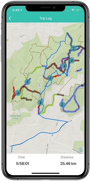
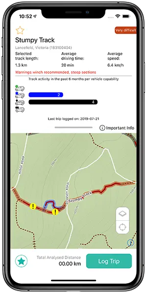
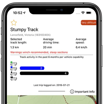
Track difficulty & stats

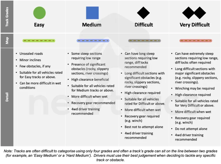
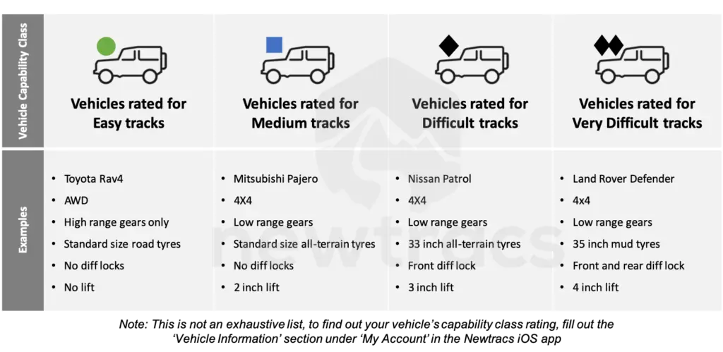
4wd track grades are assessed automatically by the Newtracs platform based on GPS traces submitted by users via the Newtracs app.  This is achieved by understanding the type of vehicle users are driving and their relative performance when navigating a 4wd track.  Other factors such as terrain are also taken into account.

Note that track grades will only be as current as the last time a Newtracs user visited that track.  For tracks visited infrequently, significant time could have passed since someone has been there last, so older track grades will be less reliable than those assessed more recently.

Our track grading methodology tries to keep in line with the standard approach developed by Four Wheel Drive Australia. An overview of this methodology can be found on their Victorian partner website at www.4wdvictoria.org.au. Please note that there is no affiliation between Newtracs and Four Wheel Drive Australia.

Offline vector maps

Newtracs offers high resolution, topographic vector maps zoomable to 1:1000 scale in both the online web map and app. Maps are sourced from OpenStreetMap. 

In addition to maps being fast to load and crystal clear, Newtracs maps can be pre-downloaded to the device to be used offline when you do not have mobile reception. 

For convenience, maps can be downloaded by state or entire country (currently Australia only), instead of being limited to selecting a small area to take offline (like HEMA, Google Maps, etc). 

For example, maps, hillshade and contour lines for the state of Victoria take up less than 500MB on device. 

Newtracs premium subscribers get access to full map detail, including hillshade and contours, at all map zoom levels. Offline maps are not available when viewing the Newtracs live web map in browser.

Vehicle profile

A key component of assessing track grades is understanding the capability of each users’ vehicle.  The Newtracs app assigns vehicle class ratings by assessing specific vehicle components as entered by the user when completing an in-app vehicle profile.  Capability components include drive train enhancements, suspension modifications, upgraded tyres and transmission type.  Vehicle capability can be enhanced in many other ways but these are considered the most impactful.

You can also use the vehicle class rating to get an understanding of which tracks your vehicle is setup to best handle.  You can see which rating Newtracs will assign to your vehicle by filling in the ‘Vehicle Details’ section within the Newtracs app.  (Account > Vehicle Details).

The Newtracs vehicle class ratings methodology draws inspiration from the track grading methodology developed by Four Wheel Drive Australia.  An overview of this can be found on their Victorian partner website at www.4wdvictoria.org.au.  Please note that there is no affiliation between Newtracs and Four Wheel Drive Victoria.

Log your trip

Logging 4wd trips lies at the heart of the Newtracs platform. Newtracs analyses user logged trips to determine conditions of 4wd tracks automatically, so that users don’t need to input any info if they don’t want to (or are too busy keeping their rig right side up!).

Logging trips is exclusively handled by the Newtracs app. To log a trip simply click ‘Log trip’ on the main map screen. A prompt will then confirm if you are traveling with a trailer. Once the log is stopped, a final prompt will confirm the details of the vehicle you have used to the log the trip.

Logged trips are then synced to our servers to be analysed alongside other users logs. Once analysed, a calculation of the number of KMs a user has submitted to be analysed will be shown in app the next time you are online. Click on your analysed KMs to see a leader board of users with the most KMs submitted.

It is important that details in your vehicle profile are accurate as these are used in determining track grades and road conditions.

Drop pins

Users of the Newtracs app are able to drop pins and save these for later viewing.  The app allows for 4 different types of pins to be dropped:

  • campsite
  • track obstacle
  • track blockage
  • generic

Dropped pin info can be customised, including name and description.  The type of pin can also be changed (e.g. from campsite to obstacle etc).

A handy feature in-app allows a pin to be quickly dropped with one touch when the app is centered on the user’s location. 

Dropped pins are synced to a user’s Newtracs profile so that all saved pins are available in any device the user logs into.

Dropping and saving pins is available to both free and paid users of the Newtracs app.  Pins are not available on the live web map.

Track obstacles

Zooming in on tracks reveals more information, including location of problem sections and obstacles.  These are identified and added to the map automatically by assessing user trip logs.

Problem sections (highlighted in red on the track) show areas where a user may have  struggled to get through a section of track.

Steep sections (marked with short perpendicular lines across a track) can be used to quickly see where a track is steep.  Any slope gradient greater than 20% is marked on the map, even for tracks with no user data.

Major obstacles (yellow circle with exclamation mark) are points along the track that may be especially difficult to traverse, or where users have struggled significantly to get through.  This includes points where the user may have had to winch.

Problem sections and major obstacles are only available on the live web map or to Premium subscribers of the Newtracs app.

5.7_closures

Closed tracks layer

A closed tracks layer is available to Newtracs Premium, which can be toggled on and off the map via filters.  Closed trails information is updated daily from DELWP and VicTraffic APIs, and can be viewed both online and offline.

Note: these layers are created from government data sources. Occasionally, it can take time for government sources to be updated, causing some trails to be marked as closed when not actually closed and vice-versa.  Newtracs endeavours to continually monitors this to update closures when made aware.